Author Topic: Yosemite National Park and the Eastern Sierra, California  (Read 8287 times)

Bill De Jager

  • NG Supporter
  • **
  • Posts: 578
Yosemite National Park and the Eastern Sierra, California
« on: December 05, 2016, 03:17:57 »
Yosemite National Park is world-famous.  The name elicits mental images of all the famous sights there such as Half Dome and Yosemite Falls. Many people, including many Californians, think that's all the park has to offer.  However, those famous sights are nearly all located in or adjacent to Yosemite Valley, a very small part of the park.  The rest of the park gets a fraction of the use that the valley gets, which I why I usually avoid the valley.  Eventually I must return there, of course, and during a lesser-used time of year such as winter.  That time has not come yet, but perhaps next year after I retire.

THE PLACE

The park is located on the west slope of the Sierra Nevada range of California.  It has tremendous variety, with elevations from 600 meters to 4000 meters and environments ranging from the extremes of hot dry foothills of Mediterranean climate to alpine tundra and glaciers (the glaciers unfortunately about to disappear due to warmer temperatures).  The middle elevations of the park are within one of the great coniferous forests of the world, the California montane forests, nourished by tremendous annual snowfall in its upper portions.  Portions of these middle elevations, and nearly all of the high country, are glacially sculpted.

Only one road crosses the park from west to east, the Tioga Road, named after Tioga Pass on the crest of the Sierra Nevada at the east border of the park.  The road is closed by snow most of the year, usually opening by late May.  Ninety-five percent of the park is protected from all development (including roads) as designated wilderness under the federal Wilderness Act of 1964.

Once one crosses Tioga Pass out of the park one is on the eastern side of the Sierra Nevada, a whole different world in so many ways.  This region is in a rain shadow, so everything is drier than the west side from the top of the mountains to the bottom.  Rather than dropping down into a Mediterranean climate as on the west slope, the mountains drop into a true desert climate.  This would be a cold desert east of Yosemite and a hot desert farther south.  Now we are in a true interior continental climate with harsh temperature extremes. The region east of the crest is made up of a series of endorheic basins (that is, areas that does not drain to the sea), collectively known as the Great Basin.  This region has a number of salt lakes, the most famous of which are the Great Salt Lake in Utah and Mono Lake in California.

This east slope of the Sierra Nevada is colloquially known as the Eastern Sierra.  The portion east of Yosemite is my favorite part.

MY TRAVEL

I first began going to Yosemite National Park as a small child and it's always been a part of my life.  I've often gone there during the peak of autumn color, a very pleasant time of the year.  Unfortunately I'd missed the previous autumn in the park, and had only brief autumn trips the two years before that, due to insatiable work obligations at the time.  This year I had a little more time to spare and arrived in far more relaxed condition.

I debated whether to post this here or under travel, but in the end this location make more sense.  After an initial explanation of context I'll have little to say about travel per se.

EQUIPMENT

I brought two camera systems, a compact one and a performance one.  The compact one was an Olympus EM10 with the Olympus 12-40/2.8 and the Panasonic 30-100/2.8.  The performance system was a Nikon D810 with various prime lenses, the Nikon 14-24/2.8, and the 70-200/4.  The former was easily accessible and the latter was securely locked away.

I ended up using the EM10 almost exclusively.  It was right there, and very easy to use and carry.  I ended up paying for this convenience with reduced dynamic range due to the small sensor.  Still, the camera is a trouper and the lenses performed very well.  It's a nice travel kit, and very similar to one of three travel kits Thom Hogan recently recommended.

THE PHOTOS

You won't see any photos here of the familiar sights of Yosemite because I didn't go there.  Furthermore, on my first day I arrived in mid-day and conditions were unattractively hazy, so shots of distant subjects or grand scenery would have looked rather flat.  Instead I looked closer for compositions.

My first stop was at a favorite location only a few miles inside the park, where Pacific dogwood trees (Cornus nuttallii) provide a beautiful understory to a coniferous forest, in this case incense cedars (Calocedrus decurrens):

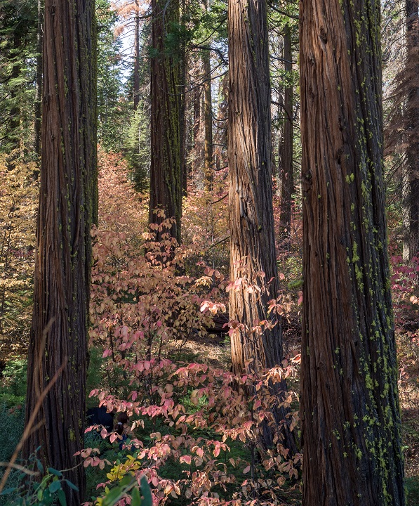
Cedars, Dogwood Hollow, Yosemite NP by Bill de Jager, on Flickr

A closeup of one of my favorite plants:

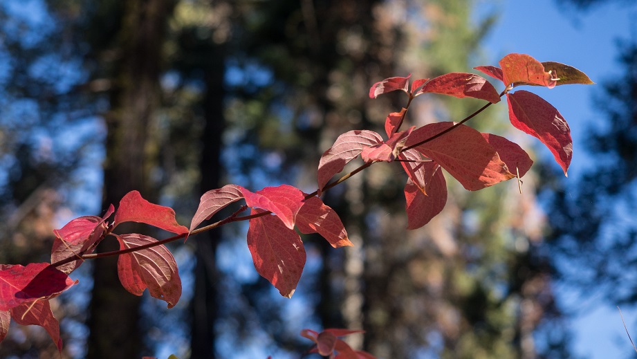
Dogwood Branch, Dogwood Hollow, Yosemite NP by Bill de Jager, on Flickr

Next was a turnout where I had stopped with my wife long ago in an April snowstorm that amazed her.  Now there was no snow, but there was a large incense cedar with an offspring:

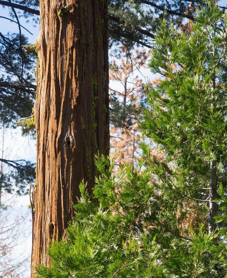
Cedars, The Turnout, Yosemite NP by Bill de Jager, on Flickr

This tree is often mistaken for the giant sequoia (Sequoiaendron giganteum) due to somewhat similar bark.  The dead trees are pines killed by bark beetles, insects which burrow through the cambium layer under the bark, eventually girdling the tree and killing it.  The ongoing drought has killed over 100 million trees in California, mostly via bark beetles.  You'll be seeing plenty of apparently healthy vegetation in these photographs due to recent increases in rain and snow, but the drought isn't over yet.

My third stop was at a former campground, now closed for about 40 years, named Smoky Jack.  I'd long been curious about this place I'd never camped at, and having recently located its former entrance I now went there to explore around.

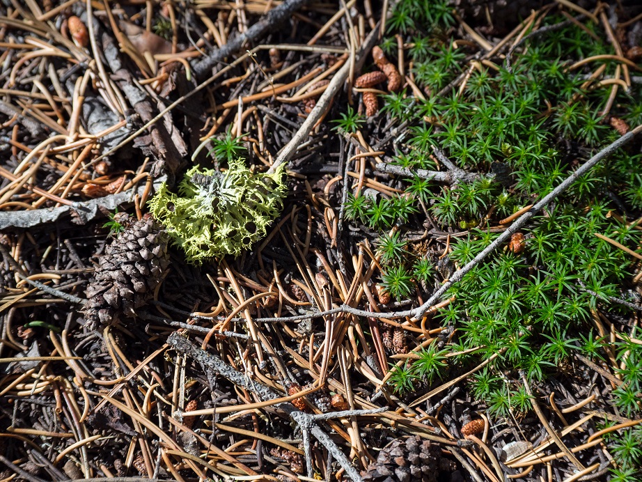
Forest Floor #1, Smoky Jack, Yosemite NP by Bill de Jager, on Flickr

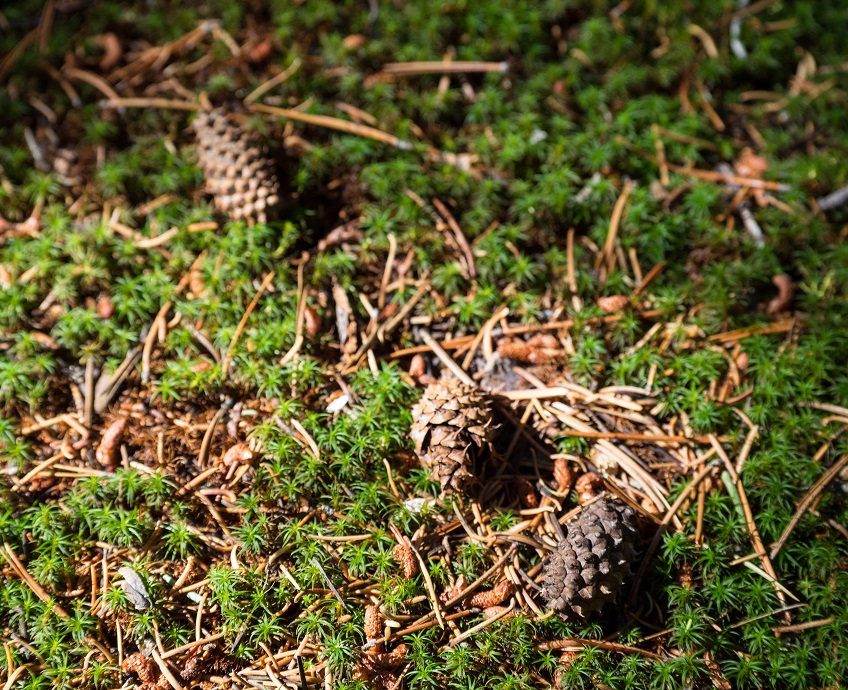
Forest Floor #2, Smoky Jack, Yosemite NP by Bill de Jager, on Flickr

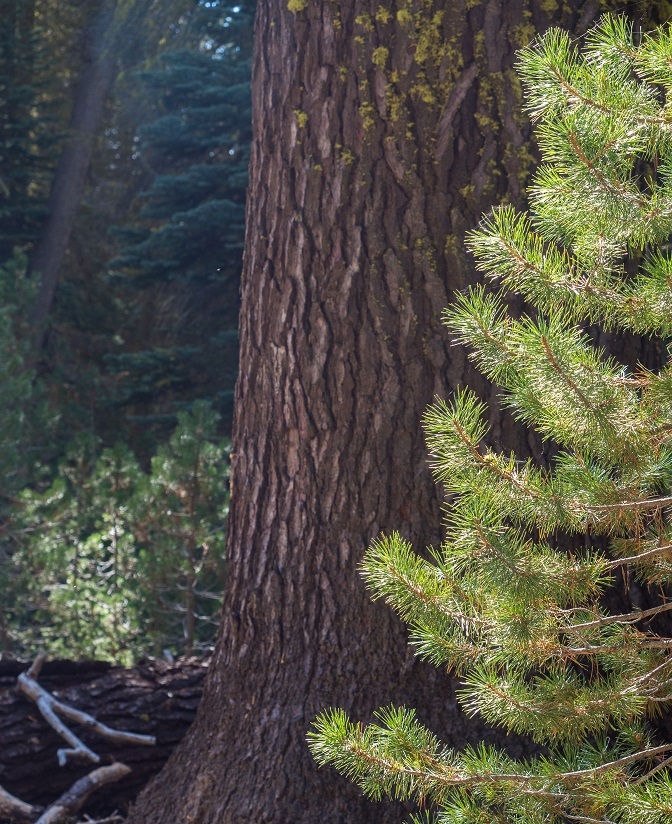
Pine and Fir, Smoky Jack, Yosemite NP by Bill de Jager, on Flickr

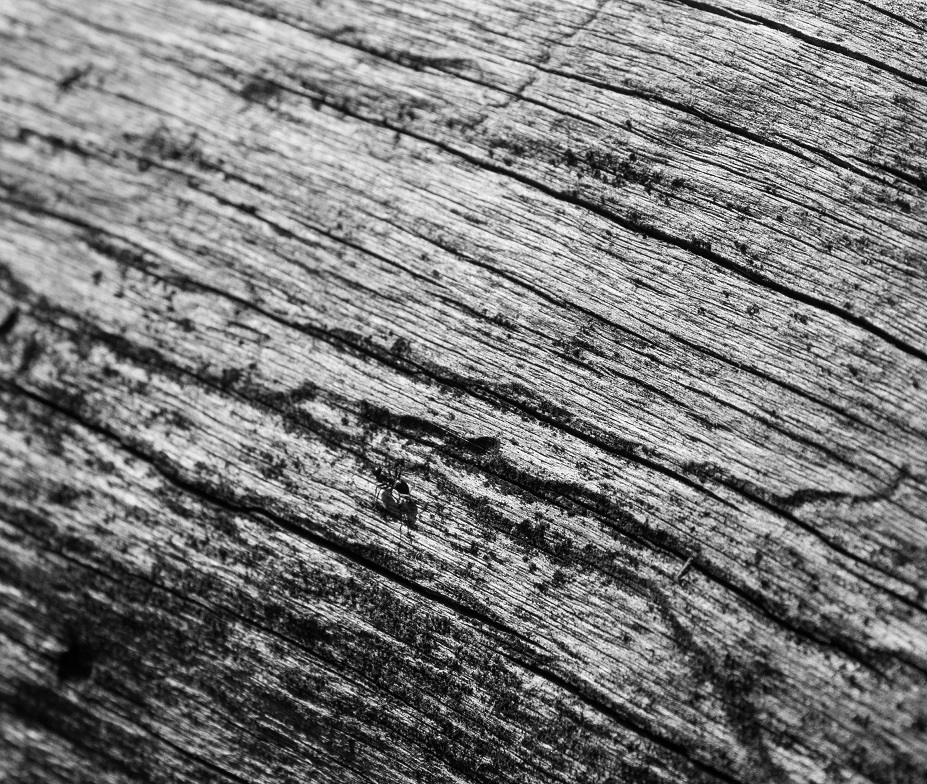
Ant and Wood, Smoky Jack, Yosemite NP by Bill de Jager, on Flickr

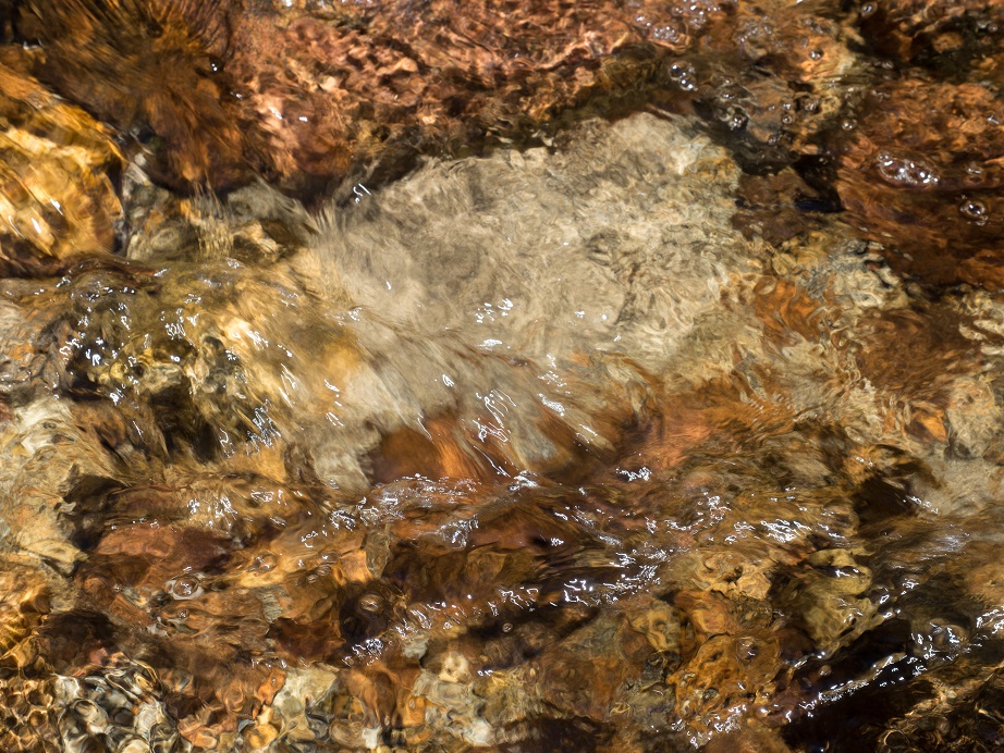
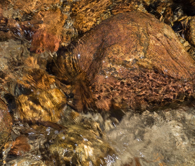
Creek #1, Smoky Jack, Yosemite NP by Bill de Jager, on Flickr

Creek #2, Smoky Jack, Yosemite NP by Bill de Jager, on Flickr

I'll have much more in time.

pluton

  • NG Supporter
  • **
  • Posts: 2610
  • You ARE NikonGear
Re: Yosemite National Park and the Eastern Sierra, California
« Reply #1 on: December 05, 2016, 05:50:14 »
Nice work, text and photos  The management of contrast and detail is lovely and doesn't look 'worked".  I like the first image best...it captures the feeling of the light and a sense of the plant community.
Keith B., Santa Monica, CA, USA

Anthony

  • NG Supporter
  • **
  • Posts: 1602
Re: Yosemite National Park and the Eastern Sierra, California
« Reply #2 on: December 05, 2016, 09:37:30 »
Bill, thanks for the photos, and for taking the time and effort to produce an interesting narrative.  I look forward to more.
Anthony Macaulay

John Geerts

  • NG Supporter
  • **
  • Posts: 9145
  • Photojournalist in Tilburg, Netherlands
    • Tilburgers
Re: Yosemite National Park and the Eastern Sierra, California
« Reply #3 on: December 05, 2016, 10:01:21 »
Great story Bill, and well illustrated.

elsa hoffmann

  • NG Member
  • *
  • Posts: 3822
  • Cape Town, South Africa
    • Elsa Hoffmann
Re: Yosemite National Park and the Eastern Sierra, California
« Reply #4 on: December 05, 2016, 10:53:52 »
thanks for sharing - I enjoyed the photos and the story
"You don’t take a photograph – you make it” – Ansel Adams. Thats why I use photoshop.
www.phototourscapetown.com
www.elsa.co.za. www.intimateimages.co.za

CS

  • NG Member
  • *
  • Posts: 1240
  • You ARE NikonGear
Re: Yosemite National Park and the Eastern Sierra, California
« Reply #5 on: December 05, 2016, 17:57:46 »


THE PHOTOS

You won't see any photos here of the familiar sights of Yosemite because I didn't go there. 

Certainly, the more famous spots in Yosemite are well worth discussion and photos. However, IMO, the Sierras have so much to see and talk about in addition to the sites seen from Yosemite Valley. Nice to see some of your shots that show there is more to Yosemite than Half Dome, etc. I do miss the easy access to the Sierras that I had for the first 40 years of my life, before I wound up here in the desert.
Carl

Bill De Jager

  • NG Supporter
  • **
  • Posts: 578
Re: Yosemite National Park and the Eastern Sierra, California
« Reply #6 on: December 06, 2016, 06:21:21 »
Thank you Keith, Anthony, John, Elsa, and Carl!

The story continues....

Some kilometers up the Tioga Road and at a higher elevation, one reaches Siesta Lake.  This is a small glacially carved lake surrounded by meadow and forest.

Fall Color, Siesta Lake, Yosemite NP by Bill de Jager, on Flickr

Sedges in the lake:

Sedges #2, Siesta Lake, Yosemite NP by Bill de Jager, on Flickr

Sedges #1, Siesta Lake, Yosemite NP by Bill de Jager, on Flickr

Pine and Webs, Siesta Lake, Yosemite NP by Bill de Jager, on Flickr

Lodgepole pine (Pinus contorta var. murrayana) bark.

Pine Bark, Siesta Lake, Yosemite NP by Bill de Jager, on Flickr

Lodgepole pine branches; note the scaly mistletoe growing out of the branches to the left.

Pine and Mistletoe, Siesta Lake, Yosemite NP by Bill de Jager, on Flickr


Bill De Jager

  • NG Supporter
  • **
  • Posts: 578
Re: Yosemite National Park and the Eastern Sierra, California
« Reply #7 on: December 11, 2016, 01:48:53 »
Continuing up the Tioga Road, one drops down into the glacially-carved valley of Yosemite Creek.  This is the creek that some kilometers farther downstream jumps off the top of Upper Yosemite Falls and then over more cascades and falls into Yosemite Valley.  Here it vigorously flows and sometimes cascades down the valley in a boreal forest.

First, the bark of the Jeffrey pine (Pinus jeffreyi), named after an early botanist.  Its bark is similar to the more widespread ponderosa pine that grow in mountain ranges across the western U.S., but with this species you can smell vanilla in the deep cracks in the bark during warm weather.
Jeffrey Pine Bark, Yosemite Creek by Bill de Jager, on Flickr

Next, the aspen (Populus tremuloides), a relative of the P. tremula of northern Eurasia.
Aspen Tree, Yosemite Creek by Bill de Jager, on Flickr

And the creek itself.
Aspen Leaf, Yosemite Creek by Bill de Jager, on Flickr

Much farther along and at a much higher elevation (2800 meters) is the place known as Dana Meadows.  The next photo is nothing special but I included it to give an little idea of the upper elevations of the park. This photo shows relatively gentle topography but many locations are far more rugged.
Dana Fork Tuolumne Meadows, October 2016 by Bill de Jager, on Flickr

The most common tree in the higher parts of the park is the Sierra Nevada lodgepole pine (Pinus contorta var. murrayana).
Lodgepole Pine Branch, Dana Meadows by Bill de Jager, on Flickr

This is almost at the the top of the Sierra Nevada.  Shortly afterwards I crossed the crest and dropped down 1000 meters to the east base of the mountains.


Frank Fremerey

  • engineering art
  • NG Supporter
  • **
  • Posts: 12362
  • Bonn, Germany
Re: Yosemite National Park and the Eastern Sierra, California
« Reply #8 on: December 11, 2016, 06:31:12 »
I love your Biologist's perspective on the subject. You see life everywhere and life in context especially. Wonderful.
You are out there. You and your camera. You can shoot or not shoot as you please. Discover the world, Your world. Show it to us. Or we might never see it.

Me: https://youpic.com/photographer/frankfremerey/

Eric Borgström

  • NG Supporter
  • **
  • Posts: 137
  • You ARE NikonGear
    • Eric´s pictures
Re: Yosemite National Park and the Eastern Sierra, California
« Reply #9 on: December 11, 2016, 15:16:44 »
Bill,
Thank you for letting us travel in one of US fantastic National Parks. I thoroughly enjoy the text and pictures.

Bill De Jager

  • NG Supporter
  • **
  • Posts: 578
Re: Yosemite National Park and the Eastern Sierra, California
« Reply #10 on: December 12, 2016, 04:10:31 »
Thank you, Frank and Eric!

That night I camped in Lee Vining Canyon on the east side of the Sierra, named after an early white settler.  Lee Vining Creek runs down the canyon and empties into Mono Lake, a hypersaline terminal lake.  (The American word canyon comes from the Spanish cañon.)  The next morning it was time to see what I could find along the creek.

We start again with the bark of a Jeffrey pine.

Jeffrey Pine Bark, Lee Vining Canyon by Bill de Jager, on Flickr

Then a somewhat abstracted view of the creek:

Lee Vining Creek Monochrome by Bill de Jager, on Flickr

The colors, water movements, and refractions in the creek were fascinating...

Lee Vining Creek #1 by Bill de Jager, on Flickr

Lee Vining Creek #2 by Bill de Jager, on Flickr

Lee Vining Creek #3 by Bill de Jager, on Flickr

Lee Vining Creek #4 by Bill de Jager, on Flickr

I finished the day in Lundy Canyon but only have one photo to share here:

Lundy Lake by Bill de Jager, on Flickr

Next up will be Mono Lake.

Bill De Jager

  • NG Supporter
  • **
  • Posts: 578
Re: Yosemite National Park and the Eastern Sierra, California
« Reply #11 on: December 21, 2016, 05:59:04 »
Mono Lake is a large saline and alkaline terminal lake (no outlet) on the east side of the Sierra Nevada.  It's at the western edge of the Great Basin, a large region of interior drainage between the Sierra Nevada and the Rocky Mountains.  The lake contains an extremely simple but incredibly productive ecosystem, with trillions of brine shimp and brine flies.  These in turn support enormous number of migratory birds, which unfortunately were not present during my visit.  The area has a cold desert climate, with warm summers but with winters getting well below zero degrees Celsius. 

Groundwater from the Sierra enters Mono Lake from under its bottom, and the calcium in the groundwater reacts with the carbonate in the lake to produce calcium carbonate (limestone).  This precipitates out of the lake water to form spires of tufa called tufa towers.  Because the lake level dropped over 10 meters during the latter half of the 20th century (due to the diversion of inflowing streams that provide part of the water supply for Los Angeles), many of the tufa towers are now above water.  While they look like salt, they are not.

Water diversions from the Mono Lake watershed are now strictly limited and the lakeshore has been protected.  However, after a period of partial recovery the lake level is again dropping due to a prolonged drought.  In the long term, efforts to save the unique ecology of the lake will probably be defeated by climate change.  You can read more here.

That said, Mono Lake can be a fantastic place to photograph in the right light.  Most tourists stop by in mid-day and make boring photographs in very flat light.  But even being there during the "golden hour" is no guarantee of worthwhile lighting.  One needs to show up prepared, hope for the best, and be ready to capitalize on any gifts nature may provide.

The following photos were taken with a Nikon D810 and the Nikkor 70-200mm f/4 lens.

In the first photo, what appears to be the far shore of the lake is actually Paoha Island.  Most of the lake is beyond this island.

Grass and Tufa by Bill de Jager, on Flickr

The dark area in the distance is volcanic Negit Island, the other large island in the lake and the former nesting ground for tens of thousands of gulls.  The mist in the distance is a dust storm kicked up by high winds crossing former lake beds exposed by dropping lake levels.  This happens often enough to create a serious air quality problem over the course of the year.

Mono Trek by Bill de Jager, on Flickr

This next one is presented in two crops; I can't decide which I like better.

Alkali Wilderness by Bill de Jager, on Flickr

Desolation by Bill de Jager, on Flickr

The final photo presented was underexposed so the details on the tufa would be visible and for dramatic effect.

Tufa Sunset 2016 by Bill de Jager, on Flickr


Anthony

  • NG Supporter
  • **
  • Posts: 1602
Re: Yosemite National Park and the Eastern Sierra, California
« Reply #12 on: December 21, 2016, 12:39:17 »
Mono Lake looks like an amazing photo location, thanks for posting.

Of the two crops presented, I marginally prefer the second, but both work IMHO.
Anthony Macaulay

Bill De Jager

  • NG Supporter
  • **
  • Posts: 578
Re: Yosemite National Park and the Eastern Sierra, California
« Reply #13 on: December 25, 2016, 17:31:28 »
Thank you, Anthony!

Bill De Jager

  • NG Supporter
  • **
  • Posts: 578
Re: Yosemite National Park and the Eastern Sierra, California
« Reply #14 on: December 25, 2016, 18:45:51 »
The next morning I headed back over the mountains, but snow had closed the pass temporarily. Eventually it was reopened and I was able to proceed through a wonderland created by the first hints of winter.  Now I'm once more using the EM10, mostly with the Olympus 12-40mm.  Longer shots are with the Panasonic 30-100mm.

Monochrome at Tioga Pass, the park entrance:

Tioga Pass Snow by Bill de Jager, on Flickr

Blowing snow on Mt. Gibbs:

Blowing Snow, Mt. Gibbs #1 by Bill de Jager, on Flickr

Meadows just below the west side of Tioga Pass:

Tioga Pass Meadow #1 by Bill de Jager, on Flickr

Tioga Pass Meadow #2 by Bill de Jager, on Flickr

Closeup of blowing snow on Mt. Gibbs, from another angle:

Blowing Snow, Mt. Gibbs #2 by Bill de Jager, on Flickr

Mt. Dana (left), Mt. Gibbs (right) and Dana Meadows:

Dana Meadows by Bill de Jager, on Flickr